Professional portable 80g tracking device designed for convenient tracking of persons, vehicles, or goods over the Internet.
GEOLOC iT200 small, compact electronic device, designed to locate persons, motor vehicles and other mobile objects.
We currently offer the equipment to pensioners at a 5% discount. They can be easily found by relatives via the web portal after entering the correct password. Unless, of course, they forget their GPS device.

Safe shopping

Fast delivery

Hassle-free return of goods
Professional portable 80g tracking device designed for convenient tracking of persons, vehicles, or goods over the Internet.
GEOLOC iT200 small, compact electronic device, designed to locate persons, motor vehicles and other mobile objects.
We currently offer the equipment to pensioners at a 5% discount. They can be easily found by relatives via the web portal after entering the correct password. Unless, of course, they forget their GPS device.
Geoloc uses two technologies for its work: GPS satellite technology for finding the location of an object and gsm mobile communication for sending data in the form of GPRS data transmission to the dispatch center.
It is powered by a 950 mAh Li-Ion battery that is recharged by a power adapter. The power adapter is included. There is no need to purchase any map documents or special software for the device. The device is a sale, without technical support from the manufacturer.
GEOLOC iT200 has a thoroughly sophisticated energy-saving system (algorithm) to keep operation on a single battery charge as long as possible. This time, of course, depends on the device's configu,GPS signal reception conditions, intensity of communication over the GSM motion network of the monitored object. The manufacturer indicates the battery operating time from 20 hours (poor conditions for receiving gps signals, permanent movement of the object, sending the position every 60 seconds for up to 4 -7 days (good conditions for receiving gps signal, occasional movement of the object, sending the position every 15 minutes during movement).
The SIM card of any mobile operator is inserted into the device. At present, the Orange data card operates seamlessly from the monthly data limit of 5MBj.
GEOLOC provides the following basic functions:
1. To find the current location by sending a one-time query.
2. Periodic transmission of the dispatch position in front of the set interval, but only if the object being monitored is moving (GEOLOC has a built-in motion sensor).
3. Sending an alarm with the current location in the following cases:
If the object being tracked leaves the territory (circle), defined by the coordinates of the center and radius if the object being tracked enters the Territory (circle), defined by the coordinates of the center and radius.
If the object under watch reaches the set altitude.
If the tracked object exceeds the permitted instant speed.
If the object being tracked passes a certain defined distance.
4. Possibility of sending special alarms:
When the battery voltage drops below the permitted level.
Every time you lose a GPS signal.
5. Save the location history to two internal memories, each with up to 25000 records.
Depending on the configuration of the device, location alarm messages can be sent in the form of GPRS data transmission. In addition to the alarm type and current location, the report also includes the following information: date, time, altitude, speed, distance travelled and base station (BTS) data of the mobile operator.
The user can communicate with the GEOLOC device as follows:
1. Using a custom SW application, the manufacturer provides a description of the communication protocol and developmental means for creating your own application.
2. Using the program "Monitor" (in English, free of charge provided by the manufacturer) which offers the following functions (using GPRS data transmission)
Mediation of GPRS communication with GEOLOC via XMPP server manufacturer (condition is pc connection to the Internet)
Set and change basic configuration parameters.
Send a query to the current location of the tracked object.
Receiving alarm messages and locations, storing them in the archive.
Display the location on the map, and the user can choose one of the following options:
a) display on custom from scanned maps.
b) display using the free map website MAPQUEST (a condition is pc connection to the Internet).
Technical parameters of the equipment:
GSM/GPRS 2-band 900/1800/1900 GPRS-enabled module.
GPS module 12-channel parallel receiver with AAGPS support and motion sensor.
Rs232 combined battery recharge connector and serial interface.
SIM card reader.
PANIC button
3x signalling LED.
950 mAh Li-Ion battery with a life span from 10 hours to 4-7 days depending on configuration, GPS signal reception conditions and intensity of communication in the GSM network.
Dimensions : 90 mm x 48 mm x 20 mm.
Weight : 80 g.
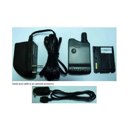
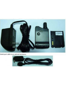
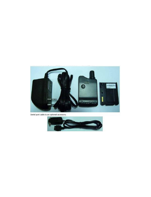
Accessories:
Charger 4,5V / 2A (included).
RS232 serial cable (not included).
Preview of the communication program "Monitor"
Mapquest
Preview a location view on a webpage
Mapquest
Abbreviated instructions:
The device is charged with the inserted charger, switched on by holding the "insignificant" button on the back of the flashlight machine for about 3-5 seconds, confirming it by tinginging with an increasing tone.
The shutdown is the same and confirms the tone in a decrease.
Device tracking is possible via the web interface:
On the page www.omniscout.com the top right corner is the MYSCOUT button. When clicked, we will see a login window where:
Account ID : omniscoutdemo
User ID : janvigas
Password : omniscout7
There's a complete environment for users to monitor, report, setup and everything the system allows. Try.
Or a sharp version:
Account id: market
User id: web
Password: on demand password
No customer reviews for the moment.
Professional portable 80g tracking device designed for convenient tracking of persons, vehicles, or goods over the Internet.
GEOLOC iT200 small, compact electronic device, designed to locate persons, motor vehicles and other mobile objects.
We currently offer the equipment to pensioners at a 5% discount. They can be easily found by relatives via the web portal after entering the correct password. Unless, of course, they forget their GPS device.